
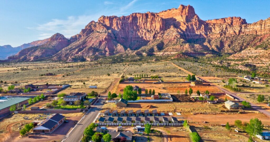
TLDR: From Cult Stronghold to Outdoor Haven: Hildale's Transformation is a story of civic change unfolding beside striking public lands. Hildale, Utah, now presents itself as a visitor base for Water Canyon and the Canaan Mountain Wilderness, but its difficult FLDS-era history remains part of the community’s living context. Come for the hiking, check current land-manager conditions, and treat the town as a real community rather than a historical curiosity.
The most useful way to understand From Cult Stronghold to Outdoor Haven: Hildale's Transformation is not as a tidy before-and-after tale. Hildale and neighboring Colorado City, Arizona, have moved through years of legal, civic, and property changes. At the same time, Hildale has begun emphasizing trails, lodging, attractions, and visitor development. The result is an unusual red-rock destination where a thoughtful trip needs room for both outdoor adventure and historical awareness.
Hildale is worth visiting, but not as a spectacle
Hildale sits on the Utah side of the state line, adjacent to Colorado City and below the sandstone country of Canaan Mountain. For hikers and road-trippers, its strongest appeal is practical: the community provides close access to Water Canyon, while Coral Pink Sand Dunes State Park and the greater Zion region offer possible additions to a longer itinerary.
The city’s official website uses “Welcome Home,” and municipal planning materials identify trails, visitor lodging, attractions, and tourism assets among its development priorities. That establishes a clear visitor-facing direction, though it does not by itself prove that tourism has transformed the local economy.
It is equally important not to turn residents’ experiences into roadside entertainment. Hildale’s history affected housing, public services, family relationships, property, and local government. Visitors can acknowledge that history without staring at homes, seeking out residents for personal stories, trespassing, or treating the community as a collection of remnants from a television documentary.
The history behind Hildale’s transformation
For decades, public life in Hildale and Colorado City was closely associated with the Fundamentalist Church of Jesus Christ of Latter-Day Saints, commonly called the FLDS. The consequences extended beyond religious identity. In 2016, a federal jury found that Hildale, Colorado City, and their joint water company had systematically discriminated against residents who were not FLDS members in housing, utilities, and policing, violating the Fair Housing Act. The case provides a documented measure of how institutional power operated in the twin towns. Readers can review the Justice Department’s account of the discrimination verdict.
Property reform was another long process rather than a single turning point. According to the United Effort Plan Trust, the trust entered Utah probate-court jurisdiction in 2005, a reformed declaration was entered on October 25, 2006, and court oversight ended when the probate case was dismissed in 2019. Those dates matter because they replace the tempting but inaccurate idea that Hildale changed through one election, one court order, or one tourism project.
The transition has continued into the present. In January 2026, the Associated Press reported that FLDS influence in the twin towns had diminished and described residents experiencing freedoms that had previously been restricted. That does not mean every social, legal, or personal consequence has disappeared. It means today’s Hildale cannot be accurately described only through the power structure that once defined it.
Start your outdoor visit at Water Canyon
Water Canyon is the clearest introduction to Hildale’s landscape. The Bureau of Land Management lists Water Canyon Arch Trail as a 3.2-mile, moderately difficult hike over sandy terrain. The canyon includes a stream and a landscape of hoodoos, pinnacles, domes, and seasonal-looking water features that should never be assumed to be reliable drinking sources.
Use the official BLM Water Canyon Arch Trail page as the starting point for current access information. Before leaving town, verify road conditions, closures, fire restrictions, parking requirements, and any applicable rules. Desert access roads can change after storms, and a map pin is not a substitute for land-manager information.
For an ordinary day hike, pack around the canyon’s exposure and variable footing rather than the moderate label alone. A sensible kit includes:
- More drinking water than you expect to need, with extra capacity during hot weather
- Sun protection, including a hat, sunscreen, and clothing that covers exposed skin
- Shoes with dependable traction on sand and sandstone
- An offline map or downloaded route information
- A small first-aid kit and an emergency light
- Warm or rain layers appropriate to the forecast and season
- A turnaround time based on daylight, weather, and the slowest person in the group
Do not count on mobile service to solve navigation or weather problems. Tell someone where you are going and when you expect to return, especially if you plan to continue beyond the shorter canyon hike.
Extend the hike toward White Domes
White Domes Trail is the logical extension for hikers who want a longer and more committing outing. BLM describes it as a 1.36-mile moderate continuation of Water Canyon Trail through the Canaan Mountain Wilderness to Sawmills Springs Trailhead. Its features include hoodoos, slickrock bowls, domes, and views toward Zion.
| Route | Best fit | What changes |
|---|---|---|
| Water Canyon Arch Trail | Visitors seeking the more straightforward introduction | BLM lists 3.2 miles, moderate difficulty, sandy terrain, a stream, and canyon formations. |
| White Domes continuation | Prepared hikers seeking more wilderness travel | The route continues into Canaan Mountain Wilderness, making navigation, weather, time, and return logistics more important. |
Published trail distances can describe a segment rather than the complete distance you will walk from your parking place and back. Build your plan from the current official route description and your intended turnaround point. If a route would leave you at a different trailhead, decide how the return will work before starting. “We’ll sort it out up there” is rarely an excellent shuttle plan.
Wilderness terrain also rewards restraint. Stay on durable surfaces where a route is established, pack out everything you carry in, and avoid creating shortcuts across fragile ground. These habits align with practical Leave No Trace principles for hikers and campers.
Flash floods can change the plan completely
Water Canyon’s name is a useful reminder that weather elsewhere can matter where you are standing. BLM warns that flash floods may occur after heavy rainfall even when no rain is falling at your location. Narrow canyons can become deadly during a flood.
Check the weather for the canyon and the surrounding drainage, not just Hildale’s hourly forecast. If thunderstorms or heavy rain are possible, choose an open-terrain activity or postpone the hike. Darkening water, rising flow, accumulating debris, thunder, or a sudden change in water sound are reasons to move toward higher ground immediately rather than wait for visual confirmation of a flood.
The practical decision rule is simple: if you cannot confidently interpret the weather and drainage risk, do not enter constricted canyon terrain. Review the BLM flash-flood guidance before the trip, then make a fresh decision on the day rather than relying on a forecast saved earlier in the week.
Add Coral Pink Sand Dunes or the Zion region
Coral Pink Sand Dunes State Park makes a useful nearby addition because it offers a different landscape and style of recreation. Utah State Parks describes it as a shifting dune environment with both nonmotorized recreation and designated opportunities for off-highway vehicles. Check the park’s official page for current fees, hours, access, and OHV rules before making the drive.
If you are not riding, plan around walking on loose sand, sun exposure, and wind. Sand travel is slower and more tiring than its mileage suggests. Keep vehicle traffic zones in mind, follow posted boundaries, and protect cameras and electronics from blowing grit.
Travelers building a wider southwest Utah itinerary can also connect Hildale with Zion-area stops. A winter hike on Zion’s Sand Bench Trail offers one possible seasonal contrast, but park access, shuttle operations, trail conditions, and weather should always be checked separately. Hildale works best as one component of a regional trip, not merely overflow lodging for a national park.
Where to stay, eat, and slow down
Hildale’s visitor economy includes locally listed lodging and hospitality businesses, but operating days and offerings can change. Water Canyon Winery states that its Hildale winery opened in 2021 and offers wine tasting, food, and events. The city’s business directory also lists Zion Glamping Adventures on North Water Canyon Road. Contact businesses directly for current hours, reservations, seasonal availability, age requirements, and event details before building a day around them.
A good overnight plan leaves some flexibility. Book lodging first, identify where you will eat or buy supplies, download your maps, and confirm whether late arrival creates check-in problems. Small destination communities may not have the same late-night services as a major park gateway. Carrying breakfast and trail food also keeps a closed café from becoming the morning’s main adventure.
A respectful first-time Hildale itinerary
For a simple one-night visit, arrive with enough daylight to find your lodging and understand the Water Canyon access route. Check the forecast and official trail information that evening. Start the Water Canyon hike early the next morning, using weather, daylight, and group ability to decide whether to turn around on the main route or continue toward White Domes.
After the hike, spend time at a currently operating local business rather than driving through residential streets in search of historical landmarks. If weather rules out the canyon, switch to an open, managed attraction such as Coral Pink Sand Dunes, provided its own conditions and access are suitable.
Hildale’s strongest future as an outdoor destination does not require erasing its past or packaging that past for entertainment. The better approach is to understand the documented history, recognize the long civic transition, and engage with the community as it exists now.
Plan for the landscape that is there today
Hildale now offers something distinctive: immediate access to sculpted sandstone terrain alongside a community undergoing visible, unfinished change. Water Canyon is the natural centerpiece, White Domes adds a more ambitious option, and Coral Pink Sand Dunes can round out a regional itinerary.
Your next step is to choose a route that fits your group, consult the official BLM or state-park page, check the full drainage forecast, and confirm local reservations directly. Arrive prepared for desert conditions and with enough curiosity to appreciate Hildale without reducing it to either its hardest history or its newest visitor pitch.
References
- Home | Hildale, Utah
- www.hildale.gov
- Office of Public Affairs | Justice Department Wins Religious Discrimination Lawsuit Against Colorado City, Arizona, and Hildale, Utah | United States Department of Justice
- More Information
- Polygamous sect's sway has dwindled in twin towns on Arizona-Utah line. Residents enjoy new freedoms
- Water Canyon Arch Trail – Utah | Bureau of Land Management
- White Domes Trail – Utah | Bureau of Land Management
- blisssmag.com
- Flash Floods: Tread Safely | Bureau of Land Management
- Coral Pink Sand Dunes State Park | Utah State Parks
- Restaurant, Cafe & Winery | Hildale & Springdale, UT | Water Canyon Winery
- Zion Glamping Adventures, LLC | Hildale UT